
Multi-hazards Shanghai - risk analysis and safety management system
 0
0
Abstract
Modern cities are prone to various natural and human-made hazards. To deal with these challenges, an effective risk analysis, reduction and management tool is required for all relevant threats. In recent years, a risk analysis and safety management system called the Multi-Hazards Shanghai (MH-SH) system was developed by the Shanghai Institute of Disaster Prevention and Relief to serve the policy makers of government in Shanghai for various disaster decision making of prevention and mitigation. The system can handle various disasters including earthquake, flood, typhoon and man-made fire that affect the operational security of Shanghai. In the paper, the general frame of the MH-SH system was briefly presented. Advanced methodologies and technologies were discussed for their capability of enhancing the platform in multi-disaster monitoring, detection, prediction and management. Finally, the way to the future development of the MH-SH system was concluded.
Keywords
BACKGROUND
Urbanization is one of the most salient features characterizing human civilization during the past millennium. According to the United Nations[1], more than four billion people now live in urban areas. By 2050, urbanization will continue to grow, adding another two billion people to reside in urban areas. After that, the world will enter “the century of the city”[2]. China is a typical example of urbanization. According to the investigation by Jin et al., urbanization in China is one of the most important events in human civilization[3]. From 1978 to 2010, the urban area in China increased from 19.7% to 49.7%, and the number of cities increased from 193 to 663[4]. By 2035, the urbanization rate of China will reach around 75%. In the near future, megalopolis surrounding megacities will become the main growth source of the national social and economic development.
The high levels of urbanization result in high levels of economic and social development. Meanwhile, the increased population, information and wealth bring greater challenges to resource consumption, waste disposal, environmental protection and socioeconomic problem[5]. Among these challenges, how to manage urban security is one of the important matters. As climate change becomes more and more apparent, cities are prone to different natural and man-made hazards, including earthquake, flood, typhoon, landslide, fire and environmental pollution. These hazards threaten urban security, causing damage to the man-made environment, loss of human life and property, and repercussion on social and economic activity.
Compared to agrarian region, urban region generally amplifies the effect of natural and man-made disasters in the following four aspects. The first one is to amplify the spatial effect. In urban areas, the effect of natural and man-made disasters interacted due to the spatial distribution of hazard-bearing body, causing a series of secondary or derivative disasters. For a defined area, the spatial interaction is so complicated that multiple hazards would share the aim of involving all relevant processes[6,7]. The second one is to amplify the population effect. Different from agrarian region, urban area has higher population density. Then emergency management and disaster rescue become more difficult, causing an amplification of causalities and a deeper memory of social and psychological impacts. The third one is to amplify the economic effect, as modern cities are engines of economic growth. A number of business activities are incorporated. Then if natural disasters happen, business activities would be disrupted at different levels in a chain reaction. The fourth one is to amplify the network effect. In modern cities, lifeline networks such as water supply network, gas transmission network and electrical network are vital infrastructure systems. These systems are interacted and coupled. Once a disaster occurs, natural and man-made hazards can spread through these infrastructure systems to form a cascading failure or regional interruption. Then it is more difficult to predict, control and manage the failure of networks and the city requires longer recovery cycles.
Therefore, how to predict and manage natural and man-made hazards in modern cities is challenging[8,9]. Different from single hazard event, all threats induced by multiple hazards should be considered, analyzed and evaluated by city managers through effective risk prediction and management strategies[10]. Unfortunately, natural and man-made hazards such as earthquake, wind, fire and flood have different characteristics. To deal with these challenges, the concept of multi-hazards initially appeared in Agenda 21 for sustainable development. As a part of human settlement planning and management in disaster-prone areas, the concept of multi-hazards refers to an integrated and inclusive approach to address vulnerability assessment, risk evaluation and disaster management, including prevention, mitigation, reduction, preparedness, response and recovery.
In recent years, the need to predict and manage multi-hazards for modern cities has been universally acknowledged. From a global perspective, various platforms have been developed at a national level. The typical ones are HAZUS, RiskScape and CAPRA. The HAZUS is one of the most popular and famous platforms developed by the Federal Emergency Management Agency (FEMA) for the United States. It is capable of estimating the potential losses resulting from earthquake, flood and hurricane. The RiskScape is a software for modelling potential multi-hazards for New Zealand. It could estimate the direct and indirect losses induced by earthquake, flood, wind storm, tsunamis and volcanic activity. Similar to HAZUS and RiskScape, the CAPRA is a GIS-based platform to address a variety of natural hazards under the support of the Global Facility for Disaster Reduction and Recovery (GFDRR) for the countries of Central America, including Belize, Costa Rica, El Salvador, Guatemala, Honduras, and Nicaragua Panama. This platform includes typical hazards such as earthquake, flood, hurricane, landslide, tsunamis and volcanic activity.
GENERAL FRAME OF MH-SH SYSTEM
In addition to the platform developed at a national scale, multi-hazards management platform developed at the city scale is becoming popular in recent years. The Multi-Hazards Shanghai (MH-SH) system developed by the Shanghai Institute Disaster Prevention and Relief (SIDPR) is a typical example. The MH-SH system is a policy support platform to guide decision making in different disaster resistance and mitigation for the city of Shanghai. Focusing on the need to ensure the safety of daily operations and the purpose of building a resilient city, the MH-SH system was developed for Shanghai city to provide multi-disaster risk prediction and urban security management.
Figure 1 shows the general frame of the MH-SH system. As observed, the platform follows a data-driven technology to provide security services ranging from disaster risk index, instantaneous early warning, dynamic risk management to emergency assistant decision making.
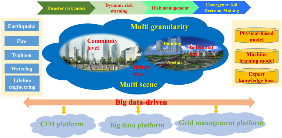
Figure 1. General frame of Multi-Hazards Shanghai.
The data-driven technology of the MH-SH system is formed by three layers, namely CIM layer, big data layer and grid management layer. The CIM layer is an important data source to provide the geographic spatial distribution of building groups and infrastructure systems by combining Building Information Model (BIM) and Geographic Information System (GIS). In the CIM layer, city parts at different levels of details (LoDs) are represented, and the data are static and historical, which are described by a vast collection of points, lines, surfaces and networks. The big data layer and grid management layer are other important data sources to drive multi-hazards prediction and deliver disaster early warning. Different from the data of the CIM layer, the data from the grid management layer are real-time, having multi-source and heterogeneous characteristics.
For the multi-disaster model, the MH-SH system includes physical-based model, machine learning model, empirical-based model and expert knowledge model, etc. These models follow strict terminology, definition and approach of each disaster discipline, but the same output in terms of the risk index is produced. Given the MH-SH system is developed with the purpose of serving Shanghai and extending the possibility for other cities, these models are developed with multi-granularity features. In other words, the MH-SH system can predict and manage multi-hazards based on where the data source is obtained and how the data structure is elaborated. Herein, it should be noted that these models are unique for the city, which are related to disaster environment, exposure distribution and developing emphases.
For the management objects, the MH-SH system includes two types of hazard bearing bodies, namely building cluster and infrastructure systems. The hazards and risks of building clusters induced by earthquake, typhoon, flood and fire are modelled and predicted, respectively. For the infrastructure system, leaking and bursting induced by corrosion, degradation, ground settlement, traffic load and third-party damage are modelled and predicted, respectively. In the MH-SH, the historical records and monitoring data are collected to verify and validate the prediction accuracy of each disaster. In order to serve different customers, the multi-disaster risk prediction results are illustrated at three scales, respectively: individual scale, community scale and urban scale. Given that city managers require scenario-target function in urban security management, the MH-SH system can also provide multi-scene prediction and management.
For the new development of the MH-SH system, advanced methodologies and technologies are implementing into the platform to improve its capability in monitoring, detection, prediction and management of multi-hazards. These methodologies and technologies include Internet of Things (IoT), Wireless Sensor Network (WSN), Satellite Remote Sensing (SRS), Unmanned Aerial Vehicle (UAV), Big Data Analytics (BDA), cloud computing (CC) and Artificial Intelligence (AI), etc.[11]. Among these technologies, AI is a promising way to solve complex system, which cannot be well addressed by traditional approaches[12,13]. Compared to traditional procedures, AI has its own superiority and advantages. For example, it can predict hazard distribution by combing different sources of data effectively.
FUTURE DEVELOPMENT OF MH-SH SYSTEM
It should be noted that the MH-SH system development is still on the way. The following three aspects are the purpose that the platform can finalize in the end.
The first one is to improve the MH-SH system from disaster risk warning to disaster risk management. Disaster risk management involves evaluation, prediction, reduction, preparedness, response and recovery. As a broader conceptual framework dealing with the multi-hazards, disaster risk management will be more beneficial for city managers. To realize this purpose, comprehensive cooperation with scientists, engineers, federal and local managers, public and private sectors and individuals is required.
The second one is to improve the MH-SH system from regional management to community management, from system management to individual management. Such improvement is helpful for the effective distribution and allocation of emergency resources. This is extremely important for the finalization of delicacy management.
The third one is to improve the platform from an elementary intelligence system to an autonomous intelligence system. Actually, establishing an autonomous intelligence system is a rite of passage for the prediction and management of multi-hazards, as it can enhance the management capacity in an evolving manner for city managers.
DECLARATIONS
Authors’ contributionsThe author contributed solely to the article.
Availability of data and materialsNot applicable.
Financial support and sponsorshipNone.
Conflicts of interestThe author declared that there are no conflicts of interest.
Ethical approval and consent to participateNot applicable.
Consent for publicationNot applicable.
Copyright© The Author(s) 2023.
REFERENCES
1. United Nations. World urbanization prospects: the 2014 revision. Department of economic and Social Affairs 2014. Available from: https://population.un.org/wup/publications/files/wup2014-report.pdf [Last accessed on 13 Jan 2023].
3. Jin X, Long Y, Sun W, Lu Y, Yang X, Tang J. Evaluating cities’ vitality and identifying ghost cities in China with emerging geographical data. Cities 2017;63:98-109.
4. Wang L, Li C, Ying Q, et al. China’s urban expansion from 1990 to 2010 determined with satellite remote sensing. Chin Sci Bull 2012;57:2802-12.
5. Wu J, Xiang WN, Zhao J. Urban ecology in China: historical developments and future directions. Landsc Urban Plan 2014;125:222-33.
6. Bathrellos GD, Skilodimou HD, Chousianitis K, Youssef AM, Pradhan B. Suitability estimation for urban development using multi-hazard assessment map. Sci Total Environ 2017;575:119-34.
7. Kappes MS, Keiler M, von Elverfeldt K, Glade T. Challenges of analyzing multi-hazard risk: a review. Nat Hazards 2012;64:1925-58.
8. Klopp JM, Petretta DL. The urban sustainable development goal: indicators, complexity and the politics of measuring cities. Cities 2017;63:92-7.
9. Wang J, He Z, Weng W. A review of the research into the relations between hazards in multi-hazard risk analysis. Nat Hazards 2020;104:2003-26.
10. Skilodimou HD, Bathrellos GD, Chousianitis K, Youssef AM, Pradhan B. Multi-hazard assessment modeling via multi-criteria analysis and GIS: a case study. Environ Earth Sci 2019;78.
11. Sun W, Bocchini P, Davison BD. Applications of artificial intelligence for disaster management. Nat Hazards 2020;103:2631-89.
12. Lu P, Chen S, Zheng Y. Artificial intelligence in civil engineering. Math Probl Eng 2012;2012:1-22.
Cite This Article
Export citation file: BibTeX | RIS
OAE Style
Li J. Multi-hazards Shanghai - risk analysis and safety management system. Dis Prev Res 2023;2:1. http://dx.doi.org/10.20517/dpr.2022.07
AMA Style
Li J. Multi-hazards Shanghai - risk analysis and safety management system. Disaster Prevention and Resilience. 2023; 2(1): 1. http://dx.doi.org/10.20517/dpr.2022.07
Chicago/Turabian Style
Li, Jie. 2023. "Multi-hazards Shanghai - risk analysis and safety management system" Disaster Prevention and Resilience. 2, no.1: 1. http://dx.doi.org/10.20517/dpr.2022.07
ACS Style
Li, J. Multi-hazards Shanghai - risk analysis and safety management system. Dis. Prev. Res. 2023, 2, 1. http://dx.doi.org/10.20517/dpr.2022.07
About This Article
Special Issue
Copyright

Data & Comments
Data
0

 Cite This Article 13 clicks

 Like This Article 19
likes
Like This Article 19
likes


Comments
Comments must be written in English. Spam, offensive content, impersonation, and private information will not be permitted. If any comment is reported and identified as inappropriate content by OAE staff, the comment will be removed without notice. If you have any queries or need any help, please contact us at support@oaepublish.com.